A six-mile hiking and biking trail through one of the most restricted landscapes in San Mateo County opens to the public Monday, Aug. 24, giving residents a new form of self-guided access to a stretch of the 23,000-acre Peninsula Watershed.
The Skyline Watershed Ridge Trail, built on San Francisco Public Utilities Commission land parallel to Skyline Boulevard south of Highway 92, will be open daily from 6 a.m. to 6 p.m. for hikers, runners, cyclists and equestrians, the San Mateo Daily Journal reported. Dogs and e-bikes are not allowed. A free permit, available on the SFPUC website or at the trailhead, is required and covers groups of up to six.
The trailhead sits at the Upper Crystal Springs Reservoir Vista Point, just south of Highway 92 on Skyline Boulevard. Parking includes 22 standard vehicle spaces, five trailer spaces and two ADA-accessible spaces.
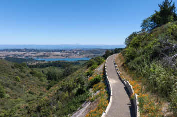
"It has really phenomenal views of the bay and, in some places, downtown San Francisco, Mount Diablo, and also the ocean," Tim Ramirez, manager of the SFPUC's Natural Resources and Lands Management Division, told KQED. He advised arriving early, as the parking lot can fill up quickly.
The trail passes through grasslands, tanoak stands, Douglas fir forest and redwood groves, with Crystal Springs Reservoir visible from an elevated stretch on a steep, open hillside. Ten interpretive panels along the route cover watershed wildlife, plant pathogens and the history of Interstate 280. Pit toilets are located at mile markers 2 and 5.
Because the trail dead-ends at the boundary of the Golden Gate National Recreation Area's Phleger Estate, visitors must retrace their steps for a 12-mile round trip.
$25 million project, decades in the making
The watershed has been largely off-limits for most of San Francisco's history. The SFPUC opened the Fifield-Cahill Ridge Trail in 2003, but that 10-mile route requires a docent-led outing. The new trail is the first to let visitors come and go freely with just a permit.
Construction began in 2024 and cost approximately $25 million to $25.5 million, funded by the SFPUC and a Federal Highway Administration grant, according to the Press Democrat. Lisa Wayne, the SFPUC's watershed resources manager who led the project, said the biggest surprise during construction was how wet the ridge turned out to be, with seeps and springs throughout.
San Mateo County Supervisor Ray Mueller, whose District 3 covers cities from Pacifica to San Mateo and the unincorporated areas along the trail, attended a private opening ceremony Thursday, Aug. 20. He called the opportunities the trail provides "precious" and said it represents "a legacy to leave for future generations."
The trail is the newest segment of the Bay Area Ridge Trail, a planned 550-mile loop around the region that is about 75 percent complete. The Ridge Trail's first mile was dedicated in 1989 in San Mateo County at Purisima Creek Redwoods Preserve and Huddart County Park.
Looking ahead, the SFPUC is working with the Midpeninsula Regional Open Space District on a spur trail connecting to Purisima Creek Redwoods Preserve, which would provide a second entry point. Bay Area Ridge Trail executive director Janet McBride expects that link in about two years. The SFPUC and Caltrans are also considering a pedestrian and bicycle overpass across Highway 92 to connect the new trail with the Fifield-Cahill Ridge Trail to the north.
What to know before you go
- When: Daily, 6 a.m. to 6 p.m., starting Monday, Aug. 24
- Where: Upper Crystal Springs Reservoir Vista Point, Skyline Boulevard south of Highway 92
- Permit: Free, available at sfpuc.gov or at the trailhead; covers up to six people for the calendar year
- Parking: 22 standard spaces, five trailer spaces and two ADA-accessible spaces; arrive early
- Allowed: Hikers, runners, cyclists, equestrians
- Not allowed: Dogs, e-bikes
- Accessibility: A flat, half-mile Watershed Discovery Trail nearby offers an ADA-accessible option with interpretive signs